Atikaki 2017 Solo Trip
Part 3
Day 9
The Teapail Portage
9 miles 3 portages 2500 meters
I'm off to an early start on a beautiful morning
but it takes me awhile to figure out the first portage. There is an
old trail on the left but it became impassible after a short ways. I
eventually found it on the right side and it was an easy one. I
probably wasted 45 minutes trying to figure it out. Soon
I was on Stonehouse Lake, a pretty lake with lots of rocky
shoreline. I find the beginning of the Teapail Portage without any
problems. The
Teapail portage is consists of two segments with a small lake in
between. The first segment follows a sedge meadow and there is an
easy to follow trail as someone has passed this way earlier this year. It is
also well marked with ribbon…too well marked in my opinion. The
first segment is about 700 meters long. There is an older trail that
branches to the right but I take the more traveled one which goes to
the end of the sedge meadow before it cuts to the west and leads to the east side
of the small no name lake. There is a small
campsite on the west side of that lake and I stop there for lunch.
Soon I am off again to the south segment of the Teapail. The start
is on the left side of the valley and it took a few minutes to find
it. It is a steep climb to start but then pretty easy going the rest
of the portage. This segment is about 1500 meters long and I
leapfrog my pack and canoe across. There are some nice views along
the edge of the of the sedge meadow. Despite its length,
a pretty easy portage. The far end is soft and muddy
as you put in on the Gammon River. From here you can go either left
or right as both ways will take you to Aiken Lake. This is a smaller
channel of the Gammon and with low water it looks tough to navigate
to the left. Going to the right brings you back to the main channel
of the Gammon. It is a bit shallow and you have to follow the
channel or you end up on a mud flat. It gets better as you go and
within a half mile or so the channel widens and deepens. Once I get
back on the main channel there is a portage on the right. Then a
short paddle and the next portage is on the left. However this one
is harder to find despite it being a short one. It is late afternoon
and I find a place to put up my tent so I call it a day. I don’t
even bother to scout the portage, I will figure that out in the
morning. It is a nice evening and I sit back and enjoy a nice
sunset over the Gammon River.

Start of t


Day 10
Completing the Loop
13 miles 3 portages 2400 meters
Today I will paddle out to Aiken Lake and once
at the campsite on the south end of the lake I will be backtracking
on familiar territory. But first, I have to get across this portage.
I take it in two stages and once on the far end I find the actual
portage trail. Oh well, I was on my way. I had one more little swift,
about a 1 foot step
I had to paddle up. I was able to approach it at an angle, using the
eddy for a push, I hit the step at an angle. I made it, barely as I
almost went back down it sideways. As I approach Aiken I meet a
couple of boats from the lodge on Aiken. We pass with a friendly
greeting, each wondering about the others circumstance. Again, Aiken
is calm but I still follow the islands and shoreline
as much as possible. Once I reach the campsite at the beginning of
the portage to Kosteck Lake I stop for a big lunch. A big plate of
hashbrowns fried in butter. I am only a couple days away from the
truck now and the thought of real food is starting to enter my mind.
Soon I am off on the 2100 meter portage. The Aiken to
Kosteck Portage is long but it is relatively flat and marked well
with cairns. I leapfrog across enjoying the return trips
without a load. I wished I had a pretty place like this close to
home that I could walk every day. Once I am on Kosteck it starts to
cloud over and a breeze picks up. I am paddling along looking to
make a right turn but soon I am at the end of the lake and I missed
the outlet to the other part of the lake. My paper maps did not show this corner of the lake.
I paddled back and forth a couple of times until I tried paddling
back into what looked like a dead end spruce bog. Once into the
channel it took a sharp right and there it was, the opening to the
other part of the lake. My GPS would have easily solve that problem.
Now I needed to find the food cache I had left on a small island. I
stashed it so well I had a hard time finding it but it was still
there. I would have food for the last couple of days. Soon I am at
the cutoff portage to the Broadleaf River. There is a nice campsite
overlooking Kosteck Lake and I pull up here for the evening. As has
pretty much been the norm the whole trip, and afternoon shower looks
to be brewing. There are a few sprinkles but overall a nice evening.


Day 11
The Broadleaf River
4 Miles 4 portages 1300 meters
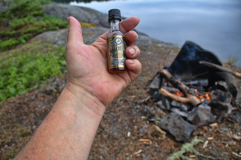
I get to start the morning off with the two part cutoff portage. I could have taken the roundabout way on the Broadleaf but chose the portage. The Teapail portage and this one are very similar. Two segments with a small lake in between. The portage goes well however I have a little trouble finding the start of the second segment despite having crossed it a week ago. It has a very steep start and I guess going up a steep face is more memorable than going down one. Also the second segment was longer than I remembered on my previous crossing. Once back on the Broadleaf, the trip back to Leaf Lake was easier and went faster than I remembered from the early part of the trip. Maybe because the beaver had dammed it up on the Leaf Lake end and the last mile was easy going compared to the shallow paddle 9 days earlier. The campsite on Leaf Lake is large and very nice. I am guessing it is used by moose or duck hunters in the fall. I enjoy a quiet evening, a nice fire, some bourbon I had been saving for the last night. I watched a gorgeous sun set over Leaf Lake as I savor the last night in canoe country.
The south segment of the Cutoff Portage


Day 12
The paddle out
17 miles 9 portages 500 meters
Despite having covered this ground a week ago,
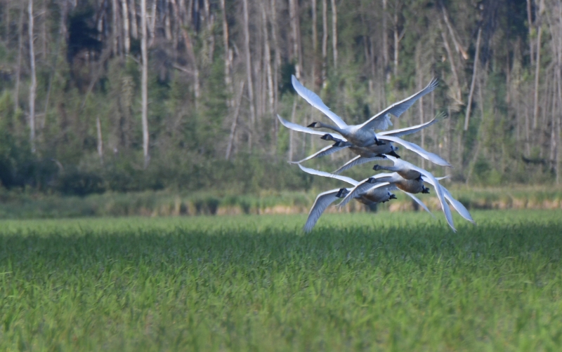
it still looks new. As I am starting out on Leaf Lake a flock
of swans do a close flyby. There are lots of short
portages on the final stretch. My body is tired and sore but each
portage brings me closer to a hot meal and a beer. As I am padding
the last stretches of the Wanipigow I dipped my hat in the water and
put it back on my head to cool off as I had done many
times on the trip. It was a minute or two later that I realized my
GoPro was no longer on my head as it normally was during the trip.
Did it fall in the water when I dipped my hat or did I lose it on
the last portage? I paddled back to the last portage and looked but
it was nowhere to be found. I had to resign myself to the fact it
was gone. Fortunately I had replaced the memory card while camped on
the Bloodvein so I at least had some of the video from the first
part of the trip. I had really relied on the GoPro to take video
along the way and had not taken as many pictures with the good
camera.
The paddle across Wallace Lake was longer than
I remembered but by mid afternoon I was back at the truck, safe and
sound. The Wallace Lake Campground was deserted midweek. Once
everything was loaded up I stopped by Wallace Lake Outposts office
and dropped off the lifejacket with a big thank you. In Bissett I
looked for a place to get a cold drink and a snack. I was able to
find Wynne’s Place just as they were closing up. There was not much
to choose from but a bag of chips and a cold root beer held me
over until I made it to Lac du Bonnet. On the North end of Lac du
Bonnet I stopped at Drifters. There I had a good burger, fries
and a cold beer before heading for the border. The border crossing
was easy and I was back at my cabin after a long day.

Final Thoughts
My 2017 trip took a lot of planning over the
long winter months. Thanks to Martin Kehoe for his help in planning and GPS
coordinates. It is great when a trip goes off as
planned, you get some good weather and the trip lives up to all the
expectations you had while preparing over the winter months. You can
spend a lot of time on Google Earth planning but the view from the
ground is always different. There were lots of long portages on this
trip and my 60 year old body held up well through 125 miles,
including 14 kilometers or 9 miles of portages. I had a
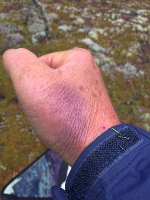
couple of slips and falls but nothing serious. My hands took a beating. I
bruised it when I fell and the rocks and blisters from paddling made them
sore. The Ford to Artery portage was
as hard as any I have done however, looking back I would do it again.
There were many highlights along the way but I think the layover day
on Artery Lake was the highpoint of the trip. If I had it to do over
again I would have spent one more day on Artery Lake. Now to plan
the next trip. I have some ideas as there are lots of wild places I
want to see from the seat of a canoe. The only criteria so far is
more time fishing and less portaging.

I hope you enjoy the virtual trip. Feedback is always welcome. I can be contacted via email at bill@hobbydog.net